This page of the site is currently under construction. Our content experts are diligently working to release new up to date content for your use. Thanks for stopping and looking around. Come back again soon to see what we have released.
Interactive Canadian Province Population Map
Other Resources
To learn more about the population of Prince Edward Island, click here
This page of the site is currently under construction. Our content experts are diligently working to release new up to date content for your use. Thanks for stopping and looking around. Come back again soon to see what we have released.
Interactive Canadian Province Population Map
Other Resources
To learn more about the population of Nunavut, click here
According to recent calculations and estimates, the population of Nova Scotia is 921,727, making it the 2nd most densely populated province in Canada.
Currently, Nova Scotia’s population makes up approximately 2.8% of the Canadian national population. With a 0.9% population growth, Nova Scotia is the seventh most populated Canadian province, after Ontario (1), Quebec (2), British Columbia (3), Alberta (4), and Manitoba (5), and Saskatchewan (6).
Nova Scotia Land Area
The land area is 55,284 km^2, or 21,345 mi^2, making Nova Scotia the second smallest province by land mass, after Prince Edward Island.
Nova Scotia makes up approximately 0.6% of Canada’s entire area and has a water area of 1,946 km^2, or 751 mi^2.
Nova Scotia Borders
The mainland of Nova Scotia is a peninsula surrounded by primarily the Atlantic Ocean. Nova Scotia is surrounded by four major bodies of water: Gulf of St. Lawrence (north), Bay of Fundy (west), Gulf of Maine (southwest), and Atlantic Ocean (southeast). Nova Scotia consists of Cape Breton Island and Stable Island, the latter being known for shipwrecks. Although surrounded by the ocean, Nova Scotia’s climate is more continental than it is maritime. However, the proximity to the ocean does contribute to the temperature extremes and cold winter/warm summer trends.
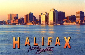
Nova Scotia Capital
Halifax is the largest city and also the capital of Nova Scotia, with a population of 390,096 according to the 2011 Census. Halifax is actually the largest city in eastern Canada. Halifax has been ranked as the “4th best place to live in Canada in 2012,” and has placed first in “large cities by quality of life” and second in “large cities in North America of the future.” Those who live in Halifax call themselves Haligonians.
Nova Scotia Federal Representation
Saskatchewan holds 11 of the 308 House of Commons seats, thus making up 3.6% of the total percentage.
Saskatchewan holds 10 of the 105 Senate Seats making up 9.5% of the total.
Nova Scotia Economic Statistics
Nova Scotia is a major economic center in eastern Canada, and has quite a concentration of private business and government buildings. One of the main employers is the Department of National Defense of Canada and other various government departments. The Port of Halifax contributes to prosperous economic trade. However, agriculture, fishing, mining, forestry, and natural gas are all important major resources in the rural areas of Nova Scotia.
Nova Scotia Historical Population Statistics
Year
Population
1901
459,574
1911
492,338
1921
523,837
1931
512,846
1941
577,962
1951
642,584
1961
737,007
1971
788,965
1981
847,442
1991
899,942
1996
909,282
2001
908,007
2006
913,462
2011
921,727
Interactive Canadian Province Population Map
Other Resources
To learn more about the population of Nova Scotia, click here
According to a 2011 estimate, the population of British Columbia is 1,208,268.
Currently, Manitoba’s population makes up approximately 3.6% of the Canadian national population. With a 5.2% population growth, Manitoba is the fifth most populated Canadian province, after Ontario (1), Quebec (2), British Columbia (3), and Alberta (4).
Manitoba Land Area
The land area is 553,556 km^2, or 213,729 mi^2, making British Columbia the eighth largest province by land mass. Manitoba has a saltwater coastline that borders the Hudson Bay and contains over 110,000 lakes, including Lake Manitoba and Lake Winnipeg, the 10th largest freshwater lake in the world. Some traditional native lands and forests on the east side of Lake Winnipeg are a proposed UNESCO World Heritage Site.
Manitoba makes up approximately 6.5% of Canada’s entire area and has a water area of 94,241 km^2, or 36,387 mi^2. It is the 8th biggest province in Canada, after Nunavut, Quebec, Northwest Territories, and Ontario, British Columbia, Alberta, and Saskatchewan.
Manitoba Borders
The west side of Manitoba is bordered by Saskatchewan, while the east is bordered by Ontario province. North of Manitoba are the Nunavut and Northwest Territories, while south of Manitoba is bordered by U.S. states North Dakota and Minnesota. Hudson Bay borders the northeast side of Manitoba.
Manitoba is the only province with both prairie and coastline. Lake Winnipeg ise the 10th largest freshwater lake in the world, and the largest in southern Canada. In addition, Hudson Bay is the 2nd largest bay in the world. Manitoba experiences a continental climate, with little precipitation the summer and extremely long Canadian winters.
Manitoba Capital
The capital of Manitoba is Winnipeg, named the Cree word for “muddy waters.” Winnipeg is located at the fork of the Red and Assiniboine Rivers and on the eastern edge of the Canadian Prairies.
Winnipeg’s population is the largest in Manitoba, with 730,018. Winnipeg is home to several professional sports teams and universities, such as theWinnipeg Jets (hockey) and Goldeyes (baseball), and the University of Manitoba, University of Winnipeg, and University of St. Boniface, the oldest post-secondary educational institution in western Canada. Winnipeg also has many cultural organizations, such as the Manitoba Theater, Manitoba Opera, Royal Winnipeg Ballet, and Winnipeg Art Gallery, to name a few. Winnipeg’s most popular festivals include the Winnipeg Jazz, Festival du Voyageur, and Folklorama.
Manitoba Federal Representation
Manitoba holds 14 of the 308 House of Commons seats, thus making up 4.5% of the total percentage.
Manitoba holds 6 of the 105 Senate Seats making up 5.7% of the total.
Manitoba Demographics
Ethnic Origins (as of 2006 Canadian Census)
English – 22.9%
German – 19.1%
Scottish – 18.5%
Ukranian – 14.7%
Irish – 13.4%
North American Indian –10.6%
Polish – 7.3%
Métis (aboriginals) – 6.4%
French – 5.6%
Dutch – 4.9%
Russian – 4.0%
Winnipeg specifically, known for its cultural diversity, has the highest percentage of Filipinos of any municipality in Canada. The Filipino language Tagalog is 2nd after English in Winnipeg. However, most Winnipeggers are of European descent, and/or classify themselves as Canadian.
One in ten people in Winnipeg speak both English and French.
Manitoba Economic Statistics
Manitoba has a moderately strong economy based largely on natural resources. The GDP of Manitoba was $50.834 billion in 2008. As of October 2009, Manitoba’s unemployment rate was 5.8 percent.
Manitoba’s economy relies heavily on agriculture, tourism, energy, oil, mining, and forestry. Due to the terrain, agriculture is found mostly in the southern half of the province, but some grain farming is in the northern part of the province. 12% of Canadian farmland is in Manitoba.
The most common type of farm found in rural areas is cattle farming (34.6%), followed by assorted grains (19.0%) and oilseed (7.9%). Manitoba is the Canada’s largest producer of sunflower seed and dry beans, and one of the leading sources of potatoes. Manitoba’s potatos are the source of McDonald’s and Wendy’s French fries. However, Manitoba’s largest employers are government and government-funded institutions, including hospitals and universities.
The Churchill port is the only arctic deep-water port in Canada and the shortest shipping route between North America and Asia. Churchill is the “polar bear capital” of the world. It is famous for beluga and polar bear watches.
Manitoba Historical Population Statistics
Year
Population
1871
25,228
1881
62,260
1891
152,506
1901
255,211
1911
461,394
1921
610,118
1931
700,139
1941
729,744
1951
776,541
1961
921,686
1971
988,245
1981
1,026,241
1991
1,091,942
1996
1,113,898
2001
1,119,583
2006
1,148,401
2011
1,208,268
Interactive Canadian Province Population Map
Other Resources
To learn more about the population of Manitoba, click here
According to calculation estimates, the population of British Columbia is 4,606,451.
Currently, British Columbia’s population makes up approximately 13.2% of the Canadian national population. Despite the 7.0% population growth Quebec has seen over the past years, British Columbia is the third most populated Canadian province. (Quebec is the second most populated province in Canada, while Ontario is the most populated province.)
British Columbia Land Area
The land area is 944,735 km^2, or 357,216 mi^2, making British Columbia the third largest province by land mass. British Columbia’s rugged coastline stretches for more than 27,000 km. This includes the recluse, mountainous fjords and about six thousand islands, most of which are uninhabited.
British Columbia makes up approximately 9.5% of Canada’s entire area and has a water area of 19,549 km^2, or 7,548 mi^2. It is the 5th biggest province in Canada, after Nunavut, Quebec, Northwest Territories, and Ontario.
Quebec Borders
The west side of British Columbia is bordered by the Pacific Ocean and parts of Alaska border the province from the north to northwest parts. North of British Columbia are the Yukon and Northwest Territories. East of British Columbia is Alberta province, and the south of British Columbia is bordered by U.S. states Montana, Idaho, and Washington. The southern border was established by the 1846 Oregon Treaty. The British Columbia coasts and southern part has many valleys with mild weather, but a majority of British Columbia experiences cold to subartic climate temperatures and typical Canadian winters.
British Columbia Cities
The capital of British Columbia is Victoria, named after Canada’s Queen of Confederation. Victoria is located on the southeastern tip of Vancouver Island. Victoria’s population is second-largest in British Columbia, with 344,615.
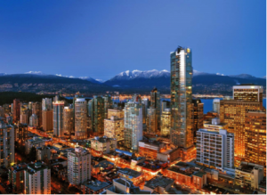
British Columbia’s largest city is Vancouver, which is actually NOT located on Vancouver Island, but on the southwest corner of the mainland (also known as the Lower Mainland), with a population of 2,313,328. For five years, Vancouver has been consistently named as part of the top-ten “world’s most livable cities.” Vancouver is also home to Port Metro Vancouver, which is the busiest and largest port in Canada. Vancouver is nicknamed “Hollywood North,” as it is one of the largest film production centers in North America (see section Economic Statistics for more info). In addition, Vancouver has been the host of the 2010 Winter Olympics and the 2010 Winter Paralympics due to its proximity to Whistler Valley, a ski resort about 80 miles from the city. Recently, Vancouver has been named the 2015 FIFA Women’s World Cup host.
British Columbia Federal Representation
British Columbia holds 36 of the 308 House of Commons seats, thus making up 11.7% of the total percentage.
British Columbia holds 6 of the 105 Senate Seats making up 5.7% of the total.
British Columbia Demographics
Of the provinces, British Columbia had the highest proportion of minorities (~24.8%). In addition, Vancouver is one of the most ethnically and linguistically diverse cities in Canada; 52% of its residents do not speak English as their first language.
Ethnic Origins
English – pop. 1,207,245 (29.6%)
Scottish – pop. 828,145 (20.7%)
Canadian – pop. 720,200 (17.7%)
Irish – pop. 618,120 (15.2%)
German – pop. 561,570 (13.8%)
Chinese – pop. 432,435 (10.6%)
French – pop. 361,215 (8.9%)
South Asian – pop. 232,370 (5.7%)
North American Indian – pop. 193,060 (4.7%)
British Columbia Economic Statistics
British Columbia is centered primarily on the forestry industry as well as an increasing interest in mining. The economy is influenced by the mining industry, but this has lead to fluctuating economic activity due to changes in commodity pricing over time. In addition, there have been economic issues concerning environmental protection, which has lead to a decreased prevalence of the mining industry in the area. Another primary industry is film/tourism; the Vancouver region in British Columbia is the 3rd largest film production location in North America, after Los Angeles and New York City, earning Vancouver the nickname, “Hollywood North.”
British Columbia’s GDP is the fourth largest in Canada at $197.93 billion in 2008. Quebec’s economy makes up approximately 12% of the total gross domestic product of Canada. The economy has primarily been driven the amount of natural resources in the area as well as the tourism element. British Columbia’s total debt will rise 16% to $47.8 billion in the 2010-11 fiscal year, or 24.3% of the total GDP.
British Columbia Historical Population Statistics
Year
Population
1851
55,000
1861
51,524
1871
36,247
1881
49,459
1891
98,173
1901
178,657
1911
524,582
1921
524,582
1931
694,263
1941
817,861
1951
1,165,210
1961
1,629,082
1971
2,184,620
1981
2,744,467
1991
3,282,061
1996
3,724,500
2001
3,907,738
2006
4,113,487
2011
4,400,057
Interactive Canadian Province Population Map
Other Resources
To learn more about the population of British Columbia, click here


 Nova Scotia Capital
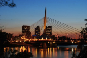 Manitoba Capital